“Tornado Alert : Particularly Dangerous Situation Warning Issued for Mississippi and Northern Louisiana Until 6 PM CDT”
The National Weather Service has warned residents to prepare for severe weather, as conditions are ripe for numerous strong, long-track tornadoes, very large hail, and damaging winds.
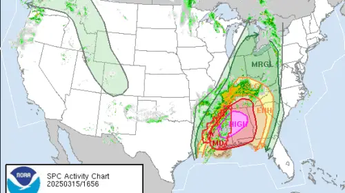
According to the Storm Prediction Center, a widespread tornado outbreak is anticipated across the central Gulf Coast States, the Deep South, and extending into the Tennessee Valley. Multiple significant tornadoes, including some that may be long-lasting and potentially violent, are forecast for this afternoon and evening. The most severe tornado risk is expected to start in eastern Louisiana and Mississippi from late morning through the afternoon, expand into Alabama late this afternoon and evening, and then move into the western Florida Panhandle and Georgia by tonight.
What does Particularly Dangerous Situation Tornado significant
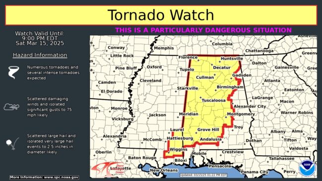
A Particularly Dangerous Situation (PDS) Tornado Watch is an uncommon and critical alert from the Storm Prediction Center (SPC), signaling a high risk of strong to violent tornadoes (EF2 or higher) across a widespread area.
- Higher Risk: Indicates an increased potential for long-track, intense tornadoes.
- Severe Impact: These tornadoes can cause catastrophic damage to buildings, infrastructure, and communities.
- Urgency: It emphasizes the need for immediate preparedness and action.